


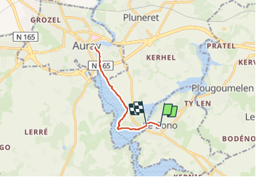
bono saint goustan

gnortier
User

Length
10.3 km

Max alt
21 m

Uphill gradient
90 m
Km-Effort
11.5 km

Min alt
0 m

Downhill gradient
99 m
Boucle
No
Creation date :
2023-06-19 08:42:33.091
Updated on :
2023-06-19 14:02:43.869
2h58
Difficulty : Easy

FREE GPS app for hiking
 SityTrail
IGN / Geographical institutes
SityTrail Plus
The world is yours!
About
Trail Walking of 10.3 km to be discovered at Brittany, Morbihan, Le Bono. This trail is proposed by gnortier.
Positioning
Country:
France
Region :
Brittany
Department/Province :
Morbihan
Municipality :
Le Bono
Location:
Unknown
Start:(Dec)
Start:(UTM)
503932 ; 5276291 (30T) N.
Comments